BUCK CREEK STATE PARK
Buck Creek State Park lies in a fertile agricultural area, rich in
Ohio's history. The park's recreational facilities center around the
2,120-acre lake, offering endless water-related opportunities.
Visitors enjoy the many wetlands, broad meadows and wildlife at
this diverse park.
The natural features of Buck Creek State Park can be attributed
to the effects of glaciers which receded from Ohio over 12,000
years ago. Low hills called moraines can be seen in the area
where glaciers halted for extended periods of time and left
deposits of gravel and sand. Old river valleys were filled by these
deposits where numerous springs now well up through the sand
and gravel. The nearby city of Springfield is named for the
many springs seeping up from the broad meadows. The springs
account for the many bogs and fens in Clark and Champaign
counties of which Cedar Bog is probably the best known.
These wet areas harbor an assortment of rare and unusual plants
including round-leaved sundew and horned bladderwort. The
spotted turtle, a state endangered animal, is found in the area.
The northernmost region of the park is an excellent area to
observe waterfowl. The shallow waters provide a stopover for
thousands of migrating ducks. Relatively rare songbirds of open
meadows are also present including dickcissels, bobolinks and
Henslow sparrows.
Buck Creek was home to Indians and pioneers. The land at the
time of early settlement was mostly forested by large trees with
minimal undergrowth. Occasionally, the forests were interrupted by prairie openings.
In 1780, George Rogers Clark, a Revolutionary war hero, led a band of nearly 1,000 Kentuckians in a raid against Ohio
Indians. The Shawnee Indians abandoned their camp which they called Old Chillicothe (near Xenia) and fled to Piqua, the
Shawnee capital, located west of the present site of Springfield. Clark pursued the fleeing Indians, and the Shawnee were
defeated at the Battle of Piqua. Most of the Indians, however, had dispersed into the woodlands. One Indian hiding in the
woods was the young Tecumseh, who vowed to avenge the attack. Following the battle, Clark's men retreated to their homes
in Kentucky and the Indians moved north. A new Piqua was erected on the banks of the Miami River. This battle put a
temporary end to Indian warfare.
With the decline of Indian threat, settlers moved into the area. In
1799, legendary frontiersman Simon Kenton settled in the
region with six other Kentucky families. The group lived near the
confluence of Buck Creek and Mad River. After two years, the
settlers moved to different areas. Kenton established a home
along Buck Creek about four miles north of present Springfield.
Settlement brought change to the area as trees were cut to
construct buildings. Acres were cleared and farm crops were
planted. The settlers found the land extremely fertile.
The community of Springfield was founded in 1801 and has
served since then as the county seat of Clark County. In 1838, the
National Road (U.S. 40) reached Springfield and this opened
new markets for manufacturing and agriculture. Over the years,
Springfield's character changed from rural to industrial. By 1880, the community led the nation in the manufacturing of
agricultural implements.
In September 1966, work was started by the U.S. Army Corps of Engineers to impound Buck Creek as a flood control project.
In 1974, the Clarence J. Brown Dam and Reservoir were dedicated and an agreement gave the Ohio Department of Natural
Resources the operation of much of the area. Buck Creek State Park was officially opened in June 1975.
Ohio does not have an annual pass and does not charge entrance fees to state parks.
GeneralLand, acres1,896
Water, acres2,120
Nearby Wildlife Area, acres284
Day-UseFishingyes
Huntingyes
Hiking Trail, miles10
Picnickingyes
Picnic Shelters, #3
Swimming Beach, feet2,400
Bridle Trails, miles8
Beach Concessionyes
Nature Centeryes
Nature Programsyes
BoatingBoating LimitsUnlimited HP
Seasonal Dock Rental186
Launch Ramps, #1
Fuel For Saleyes
CampingPrimitive, #22
Electric Sites, #89
Pets Permittedyes
Flush Toiletsyes
Dumpstationyes
Showersyes
WinterSleddingyes
Cross-Country Skiingyes
Snowmobilingyes
Ice Fishingyes
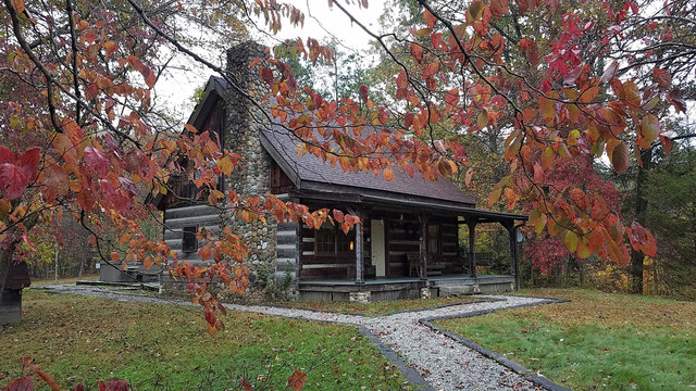
AccommodationsFamily Cottages, #26
There are 26 family cottages situated in a wooded area with several offering a view of the lake. The cottages have two
bedrooms, bath with a shower, living room with a trundle bed, complete kitchen, dining area and screened porch.
This modern campground has 101 campsites of which 89 have electricity. Campground facilities include showers, flush toilets
and dump station. Campers with pets may camp on designated sites.
Sunbathers and swimmers enjoy the 2,400-foot sand beach. A
concession stand is located at the beach.
Boating with unlimited horsepower is permitted on the 2,120-acre lake. A four-lane launch ramp provides access to the lake.
A marina provides fuel, snack bar, and bait shop.
Buck Creek State Park in Ohio offers a variety of fishing opportunities for both novice and experienced anglers. The park's main attraction is the 2,120-acre Buck Creek Lake, also known as Clarence J. Brown Reservoir.
The lake is home to several species of fish including largemouth bass, smallmouth bass, white crappie, black crappie and bluegill. Other common catches include channel catfish and saugeye (a hybrid of walleye and sauger). In addition to these native species there are occasional stockings by the Division of Wildlife with rainbow trout during spring months.
Fishing can be done from shore or boat; however motorized boats must adhere to horsepower restrictions on certain parts of the lake due its status as a drinking water reservoir for Springfield city residents.
There are two marinas located within Buck Creek State Park that offer bait sales along with other amenities such as fuel docks & snack bars: one at North Shore off Route 68 north near Clark County Fairgrounds while another lies south end close C.J.Brown Dam Visitor Center where you'll find picnic areas plus playgrounds too!
In winter when conditions permit ice-fishing becomes popular activity among locals who target panfish primarily but occasionally hook into larger predator like northern pike if they're lucky enough!
For those interested in fly fishing or catch-and-release practices - Mad River which flows through western edge this state park provides excellent habitat brown trout thanks cold groundwater springs feeding it year-round making an ideal destination regardless season/time-of-year visited here!
Remember though before heading out onto waters make sure have valid Ohio Fishing License required all individuals age 16 older unless exempted under specific circumstances outlined Department Natural Resources' regulations guidebook available online their official website www.wildohio.gov .


