MOUNT DIABLO STATE PARK
This park is one of the ecological treasures of the San Francisco Bay Area. Every season in the park has its special qualities. Discover for yourself the mountain's beautiful wildflowers, its extensive trail system, fascinating wildlife and distinctive rock formations. View the stars from its lofty heights, bike ride to its 3,849 foot summit or explore the more remote trails by horseback. The park offers hiking, biking, horseback riding and camping.
Day-UseHiking Trailyes
Swimming Beachyes
BoatingLaunch Rampsyes
Mount Diablo State Park is located near Alameda, Alamo and Antioch
Mount Diablo State Park offers scenic picnic areas with tables, grills, and restrooms at spots like Live Oak Campground.
Juniper, North Peak Trails,
?The Grand Loop? is 7 miles round trip with 500-foot elevation gain From the Golden Gate to the Farallon Islands, from the High Sierra to the Central Valley?this is the sweeping panorama you can savor from atop Mt. Diablo. Geographers claim that hikers can see more of the earth?s surface from the top of Mt. Diablo than from any other peak in the world with only one exception: Africa?s legendary 19,340-foot Mt. Kilimanjaro.
The far-reaching panorama from Mt. Diablo is all the more impressive considering the mountain?s relatively short (elevation 3,849 feet) height. Two reasons for the grand views: (1) the mountain rises solo very abruptly from its surroundings, and (2) the land surrounding the mountain?the San Franciso Bay and Central Valley?is nearly flat.
Geologically speaking, the mountain is a bit odd in that the hiker climbs over successively older and older rocks on the way to the summit; this is exactly the opposite of the usual progression. Much of Diablo?s sedimentary rock, which long ago formed an ancient sea bed, has been tilted, turned upside down and pushed up by a plug of hard red Franciscan rock.
Even those hikers without any interest in geology will be impressed by the bizarre, wind-sculpted rock formations bordering a picnic area on the mountain called ?Rock City.? The mountain?s rock show also includes the satanic-looking Devil?s Pulpit, located just below the summit.
Several colorful yarns describe how the mountain got its name. The most popular account supposedly arose from an 1806 expedition of Spanish soldiers from San Francisco Presidio who marched into the area to do battle with the local Indians. In the midst of the fighting, a shaman clad in striking plumage appeared on the mountain. The Spaniards were convinced they saw El Diablo?The Devil?and quickly retreated.
In 1851, Mt. Diablo?s summit, long a landmark for California explorers, was established as the official base point for California land surveys. Even today, Mt. Diablo?s base line and meridian lines are used in legal descriptions of much California real estate.
Toll roads up the mountain were opened in the 1870s and a fancy hotel was built. In order to make their California holiday complete, tourists of the time just had to climb Mt. Diablo and take in the majestic view.
In 1931, the upper slopes of Mt. Diablo were preserved as a state park. In more recent years, the lower slopes were added to the park, thanks in a large measure to the efforts of Save Mt. Diablo, a local conservation organization.
Today the park consists of some 19,000 acres of oak woodland, grassland and chaparral. Stands of knobcone and Coulter pine, as well as scattered digger pine, are found all over the mountain.
Mt. Diablo boasts some fine trails but the state park is primarily oriented to the automobile. Something of the majesty of conquering Diablo is lost for hikers when they?re joined at the top by dozens of visitors stepping from their cars.
Still, there are plenty of places on Diablo?s flanks where cars can?t go. And the road to the summit, while intrusive, does allow hikers to easily customize the length of their day hike.
Want an easy hike? Start walking just below the summit. Want a vigorous aerobic workout? Start hiking at the base of the mountain and trek all the way to the top.
A relatively easy way to the top is via two mile round trip Juniper Trail. More ambitious hikers will tackle the 6 mile round trip Summit Trail.
A great way to tour the park is to follow what park rangers call ?The Grand Loop,? a seven mile circuit that connects several trails and fire roads and offers views of?and from?Diablo in every direction.
Mitchell Canyon Interpretive Center
The Mitchell Canyon Interpretive Center, located in Mount Diablo State Park at the south end of Mitchell Canyon Road in Clayton, California, is staffed by park volunteers. The gift shop is supported by the Mount Diablo Interpretive Association, which works with the park to provide visitors with information so they can better enjoy Mount Diablo State Park and its natural wonders.
The Center has displays about various aspects of Mt. Diablo State Park, such as geology, wildlife, trails, and plant life. Interpretive materials about the Park, such as geology, wildlife, and plants, are for sale. There are also postcards, note cards, trail maps, and water for sale.
Offers diverse habitats like chaparral, oak woodlands, and grasslands for birdwatching. Home to golden eagles and peregrine falcons. Seasonally attracts migratory species such as warblers and thrushes. Look out for resident birds: Nuttall's woodpecker, California quail, acorn woodpeckers are common sights.
Popular spots include Curry Point and Juniper Campground for high-elevation species viewing opportunities.
Spring brings colorful displays of western tanagers; hummingbirds also frequent the area during this time.
Birders can explore trails like Mitchell Canyon or Eagle Peak Trail to spot different avian communities.
The park hosts guided bird walks occasionally which help in spotting less visible or rare birds.
Checklists available at visitor centers aid in tracking sightings including various raptors besides songbirds native to the region.
Remember binoculars essential equipment here due to expansive landscapes where many birds may be viewed from afar.
Many visitors to Mount Diablo head straight for the summit to enjoy the famous view. Summer days are sometimes hazy, and the best viewing is often on the day after a winter storm. Then, you can look to the west, beyond the Golden Gate Bridge, to the Farallon Islands; southeast to the James Lick Observatory on Mount Hamilton at 4,213 feet elevation; south to Mount Loma Prieta in the Santa Cruz Mountains at 3,791 feet elevation, north to Mount Saint Helena in the Coast Range at 4,344 feet elevation, and still farther north to Mount Lassen in the Cascades at 10,466 feet. North and east of Mount Diablo the San Joaquin and Sacramento Rivers meet to form the twisting waterways of the Delta. To the east beyond Califomia's great central valley, the crest of the Sierra Nevada seems to float in space.
Rock City
You'll find unusually large sandstone formations and small caves here.
Boy Scout Rocks and Sentinel Rock
These are popular places near Rock City for rock climbing. Check with the ranger for regulations and the best approach.
Fossil Ridge
Evidence of previous residents is embedded in these rocks. Please leave them for future visitors to see.
Deer Flat
You are likely to see some of the mountain's natural wildlife as you take this moderately strenuous 1.6-mile hike from Juniper Camp.
Mitchell Canyon Staging Area
This is the main access point to trails on the mountain's north side. From here you can hike to Deer Flat (3.7 miles) or all the way to the summit (6.8 miles) by way of Juniper Camp.
Diablo Valley Overlook
From here near Juniper Campground, 3,200 feet above sea level, you can see the Golden Gate.
Art Gallery
Rotating displays of the fine interpretive art by local artists and photographers complement the permanent exhibits.
Observation Deck
Telescopes are mounted on the deck to help visitors enjoy one of the finest views in the world. On the walk up the circular stairway to the observation deck, visitors are treated to a look at ancient marine fossils embedded in the sandstone walls of the summit building. In the rotunda they are reminded of Mt. Diablo's importance as a survey point. Above the rotunda is a beacon, historically important to aviators and now lighted once a year on December 7 in memory of those who lost their lives at Pearl Harbor.
Highway 680 to Danville; take Diablo Road exit, then 3 miles east to Mount Diablo Scenic Blvd.


 Share Your Mount Diablo State Park Photos (click here)
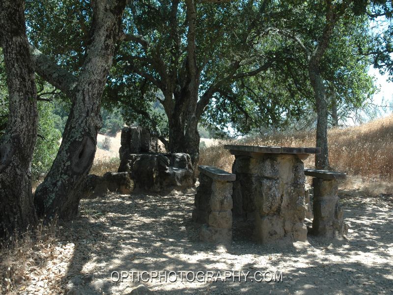